


EAST WHITELAND TWP PCT 04, Chester County, Pennsylvania
About
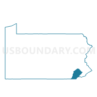
Outline

Summary
| Unique Area Identifier | 658419 |
| Name | EAST WHITELAND TWP PCT 04 |
| County | Chester County |
| State | Pennsylvania |
| Area (square miles) | 2.65 |
| Land Area (square miles) | 2.64 |
| Water Area (square miles) | 0.01 |
| % of Land Area | 99.59 |
| % of Water Area | 0.41 |
| Latitude of the Internal Point | 40.04639110 |
| Longtitude of the Internal Point | -75.55889100 |
Maps


Graphs
Select a template below for downloading or customizing gragh for EAST WHITELAND TWP PCT 04, Chester County, Pennsylvania


Neighbors
Neighoring Voting District (by Name) Neighboring Voting District on the Map
- CHARLESTOWN TWP Voting District, Chester County, PA
- EAST WHITELAND TWP PCT 02, Chester County, PA
- EAST WHITELAND TWP PCT 03, Chester County, PA
- EAST WHITELAND TWP PCT 05, Chester County, PA
- EAST WHITELAND TWP PCT 06, Chester County, PA
Top 10 Neighboring County Subdivision (by Population) Neighboring County Subdivision on the Map
- East Whiteland township, Chester County, PA (10,650)
- Charlestown township, Chester County, PA (5,671)